- This topic has 6,419 replies, 23 voices, and was last updated 1 month ago by
 Proclaimer.
- AuthorPosts
- January 12, 2020 at 1:42 pm#849327
 ProclaimerParticipant
People Cross Antarctica All the Time. It’s Still Crazy Hard
Two men are walking across Antarctica alone, together. Both are adventurous and fit: Louis Rudd, 49, a British Royal Marine combat veteran who has hiked to the South Pole before; Colin O’Brady, 33, a US adventurer who survived severe burn injuries to become a mountaineer and professional triathlete.Nov 18, 2018
A 33-year-old American explorer has become the first person to cross Antarctica alone and unassisted, after an epic race across the ice. Colin O’Brady finished the 1,500-kilometre journey in 54 days, lugging his supplies on a sled as he skied in bone-chilling temperatures.Dec 26, 2018.
So how hard is it. Read about that here.Worsley was attempting to complete Ernest Shackleton’s attempt on the South Pole, one the early 20th-century explorer abandoned about 100 miles short of completion.
The extremely badass Felicity Aston skied alone across the continent in 2012, helped by two food supply drops. Others have made the crossing assisted by kite sleds or other power sources. Cecilie Skog made the crossing with a buddy.
https://www.wired.com/2016/02/people-cross-antarctica-all-the-time-its-still-crazy-hard/
January 12, 2020 at 1:44 pm#849328 ProclaimerParticipant
US man finishes solo race across Antarctica – BBC News
In all your decades of watching nature adventure shows where people go to the most extreme places on earth (like to the bottom of the ocean and trekking across the Sahara or the outback), don’t you find it at least intriguing that NOBODY has ever done a Nat Geo or BBC show about trekking across Antarctica with sled dogs or something… with overhead views from balloons or helicopters or drones?
January 12, 2020 at 2:04 pm#849329 mikeboll64Blocked
Great. Now pick ONE of them, and let’s actually confirm it happened. Let’s start by finding aerial or satellite footage of this person in the interior of Antarctica. How about Fierce Felicity? She got two airdrops, right? Let’s see the aerial footage from the drop planes as they flew from the edge base all the way to the interior – showing Felicity on the ground from miles away as they approach her to drop the supplies.
January 12, 2020 at 2:07 pm#849330 mikeboll64Blocked
Dude, copying and pasting propaganda pieces are not helping your case. I’m asking for PROOF, or at the very least least your honest response to my logical thinking question I’ve repeatedly asked.
Whose view does Google Earth support?
January 12, 2020 at 2:13 pm#849331 mikeboll64Blocked
T8, in those Sahara treks, they always have BBC aerial camera shots where they zoom in from “outer space” and zero in on our trekkers on the ground. Do any of the Antarctica treks have this? Were live documentaries even made about these treks? Why not?
January 12, 2020 at 3:36 pm#849332 ProclaimerParticipant
Great. Now pick ONE of them, and let’s actually confirm it happened. Let’s start by finding aerial or satellite footage of this person in the interior of Antarctica.
Great. You can do Australia. You first.
January 12, 2020 at 3:54 pm#849333 mikeboll64Blocked
Okay… here’s a 1 minute short by Nat Geo I found in 5 seconds. How many aerial shots do you see?
Or better yet, let’s just pick a place in the middle of nowhere in the outback, and zoom in on Google Earth to see if it’s real or CGI pixels.
Yep, just zoomed in on a little town called Warburton in the middle of nowhere. Real houses, roads, rocks and trees. Now let’s do Antarctica.
January 12, 2020 at 6:29 pm#849334 mikeboll64Blocked
What a trip! Looks like we don’t have to do Antarctica. Another flat earther put out a video after our discussion which basically amounted to a verbal version of everything I typed today. He goes to Antarctica on Google Earth, and even talks about Captain Cook’s voyage and the other one by the British ship Challenger (I mistakenly called it “Discovery”). Anyway, I’ve got it queued, and you can watch as long as you want, but 9 minutes worth will get you through the Google Earth part and the Cook/Challenger journeys.
January 12, 2020 at 9:33 pm#849336 ProclaimerParticipant
I see. So you give this as proof that Australia exists and when we show videos or photos of the globe and of Antarctica, they don’t exist.
Got it mate. Lol.
January 12, 2020 at 9:36 pm#849337 ProclaimerParticipant
Yep, just zoomed in on a little town called Warburton in the middle of nowhere. Real houses, roads, rocks and trees. Now let’s do Antarctica.
I see. So Google up the image quality depending on population density and the Outback while sparsely populated has better imagery than Antarctica that has zero population. Hmm what is going on here. It’s a deep mystery, perhaps the earth is hollow after all, sorry I mean flat.
January 12, 2020 at 10:26 pm#849338 ProclaimerParticipant
Yep, just zoomed in on a little town called Warburton in the middle of nowhere. Real houses, roads, rocks and trees. Now let’s do Antarctica.
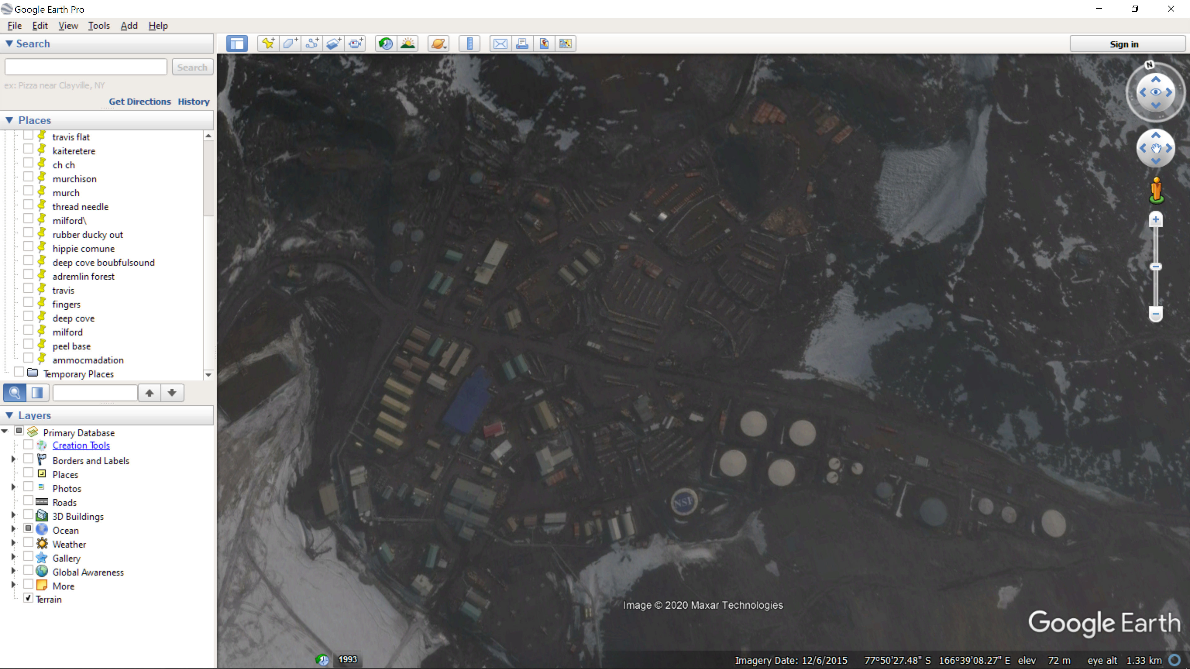
Yep, just zoomed in to Antarctica on Google Earth because it shows the continent in the correct projection and saw mountains, glaciers, flat ice plains, areas with no ice, icebergs, and even roads, buildings, and what looks like silos.
 January 13, 2020 at 12:16 am#849339
 ProclaimerParticipant
So you have no proof that Australia exists Mike. Yet you believe it exists despite no proof. You are not adhering to your own standards.
January 13, 2020 at 4:24 am#849340 Dig4truthParticipant
Mike, I saw that last video you posted the other day and I was just about to tell you about it but I see that there was no need.
It’s a very well done video!
What’s the deal with tater? All he talks about is Australia and lizard people! As if that proves something.
Do you think he will check out google earth to verify this evidence? Probably about the same odds as there being lizard people in Australia.January 13, 2020 at 4:34 am#849341 mikeboll64Blocked
If Australia actually existed, I’m sure it would be full of lizard people! 😁
January 13, 2020 at 5:29 am#849343 mikeboll64Blocked
t8: Yep, just zoomed in to Antarctica on Google Earth because it shows the continent in the correct projection and saw mountains, glaciers, flat ice plains, areas with no ice, icebergs, and even roads, buildings, and what looks like silos.
Now pick a spot in the middle of the “continent” and zoom in. Or you can just watch the 12 minute mark of that video I uploaded. His commentary at 12 minutes is hilarious.
See, you picked a spot on the edge. We all agree the edge exists. Flat earthers believe that edge forms a great circle that encompasses the earth – the “outer ring” of earth. So yes, we agree that there are many military forces and scientists from many different nations stationed on that edge. The spot you picked is in the dead center of this screenshot…
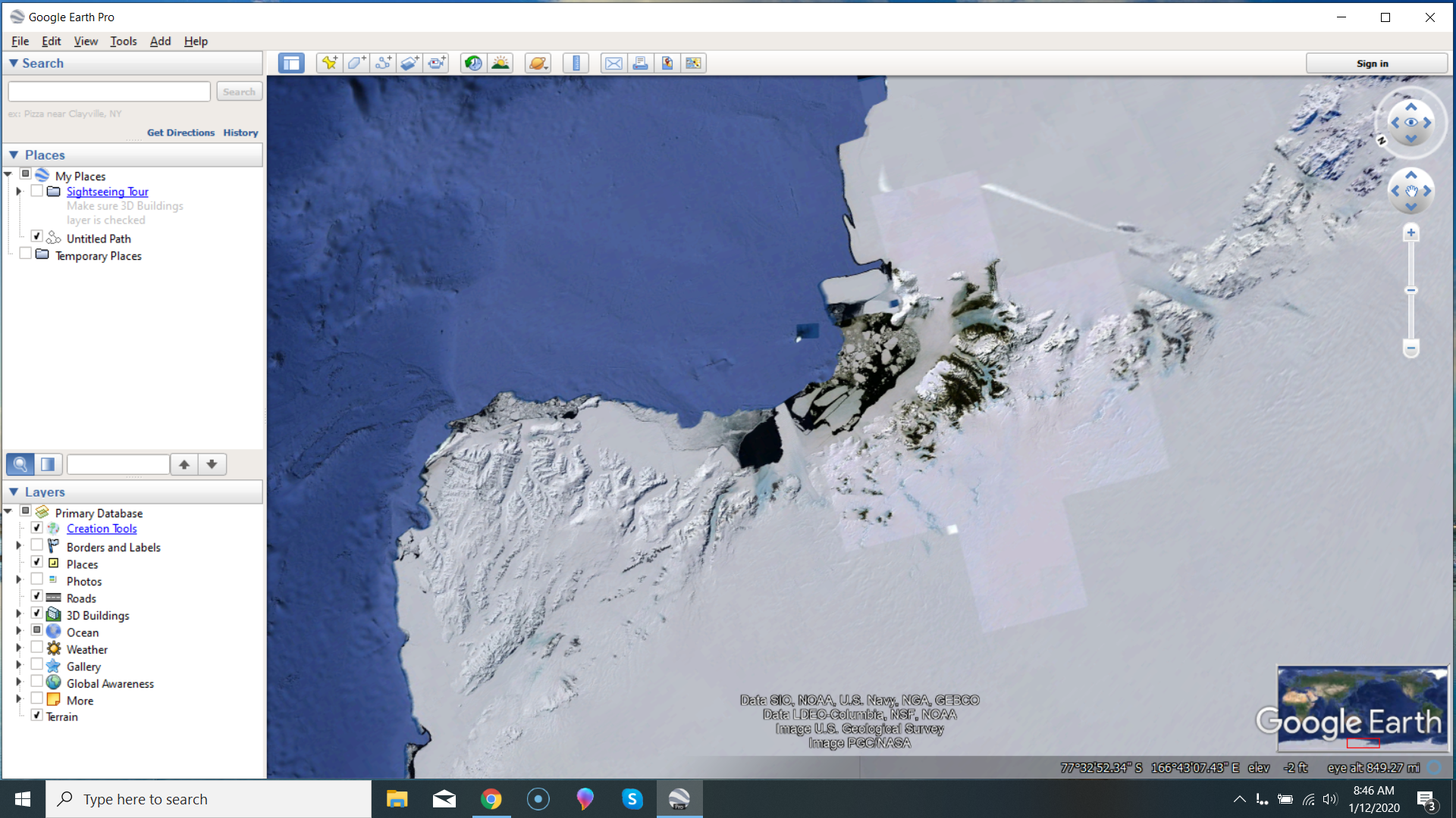
That is the edge, t8. And interestingly, look at the bottom right, where the words “Google Earth” appear. Do you see the little red box below those words, indicating the area of the earth we are currently zoomed into? Ironically, that’s what we are saying – that the Antarctic is that thin wall at the bottom of the earth (in that map projection). We agree that the portion in the red box exists. But even so, what’s with the patchwork quilt effect? Why do we have lighter squares in the middle of darker areas? I haven’t noticed that in any of my original photographs… or in any of yours. Have you? So we can tell this thing is patched together using CGI, right? Why would that be? Why not just a normal aerial photo of the area? Okay, now let’s find a spot in the middle…
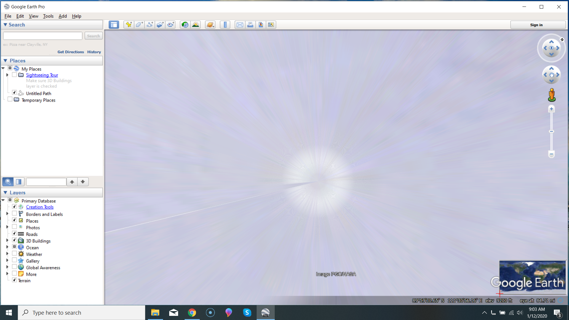
What the freak is this? Does that look like a real aerial photo to you? Dude, I’m shooting the moon going in as I write this. With my $400 P900, I can zoom in and see great detail on the moon, like this…
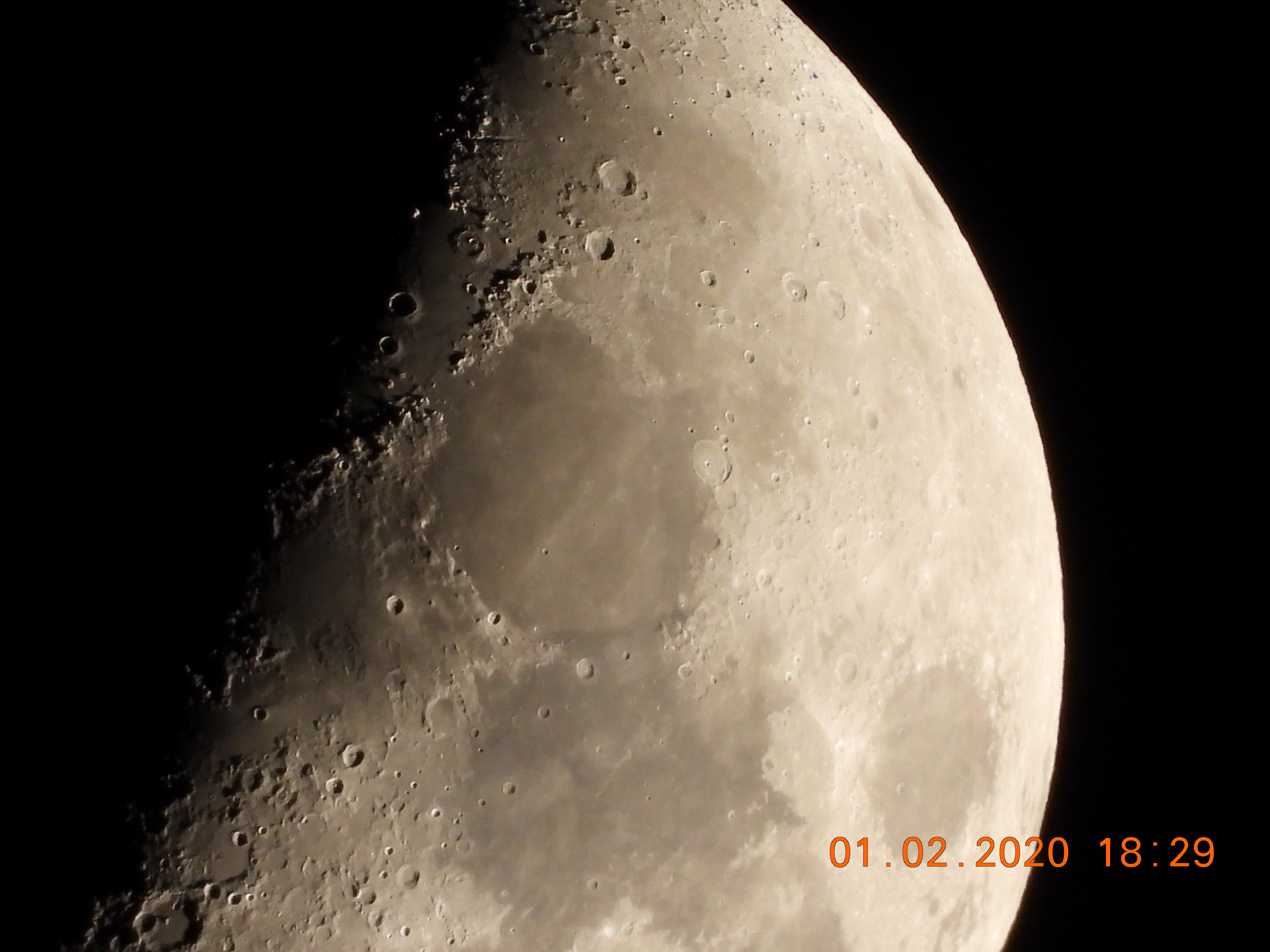
Okay… I’m supposedly 240,000 miles from this moon, right? Space satellites are supposedly about 250 miles from us. That is 1,000 times closer! High altitude balloons like Google Loon (the actual “space satellites”) are only 25 miles from us. They’re 10,000 times closer! So how can I – with a very cheap camera with one of the smallest sensors on the market – get actual photos of the moon with fairly good clarity, but the Google Loon guys with their million dollar 8K mega pixel cameras can’t get a decent quality actual photograph of inland Antarctica?
We’ve got thousands of citizens launching their own balloons with cheap GoPro cameras, right? You can see the earth all the way from ground level as the balloon rises to 22 miles or so (before it pops). So why – after many decades of professional scientists in Antarctica – can’t one of them launch a balloon from the south pole so we can see the landscape as the balloon rises? Why no actual aerial footage of this land that all of us are curious about, but know absolutely nothing about?
Let me say it again… The Google Earth CGI images of inland Antarctica is exactly what WE would expect in a world where Antarctica isn’t a continent – but a strip of high, icy land that encircles the rest of the earth. In YOUR model, there is absolutely no valid reason for there not to be millions of photos and videos and balloon footage and satellite footage and aerial footage of every square inch of Antarctica.
So whose worldview aligns with what we really have? Mine or yours? Tick tock… I’ve asked a bunch of times already. Tick tock… People are thinking you’re not quite the honest truth seeker you claim. Tick tock… Why can’t you just answer the question? Tick tock…
January 13, 2020 at 5:44 am#849344 mikeboll64Blocked
D4T: What’s the deal with tater?
😁😂🤣 Taters gonna tate!
D4T: I saw that last video you posted the other day…
FEB must have re-uploaded that video or something. YouTube has yesterday as the upload date. That’s why I thought it was so cool. I spent the morning typing all that stuff to t8, then went and watched the NFL playoffs with my Dad. Then I opened YouTube to listen to on the drive back home, and that was the top video in my feed when I opened the app. I was thinking, “Really? Perfect timing since I just spent the morning going over this stuff with t8.” And then I watched it on the way home, and was cracking up that Josh was saying everything I spent the morning typing. 😁
January 13, 2020 at 10:13 am#849345 ProclaimerParticipant
See, you picked a spot on the edge. We all agree the edge exists. Flat earthers believe that edge forms a great circle that encompasses the earth – the “outer ring” of earth.
With the trillions spent by the lizard people on keeping the conspiracy alive you would think they could CGI in the centre of Antarctica with high quality Hollywood image art work. But no, they screwed up and now the populace of planet earth is suspicious. Dumb lizards.
Or perhaps it’s just that white ice plains with zero population is not high priority as far as high quality imaging goes, after all, there are plenty of places that need image upgrades like the area where my house is located. In that instance, there is high quality imaging either side of me, while I sit in a pixelated zone for some reason. Surely Google need to fix this sort of thing before even contemplating imaging what will be plain white and will help exactly zero people find their way.
And here’s the thing. Mountains in Antarctica have good imaging and they go quite a distance inland, I guess because they are actually interesting as there are some geographical features to look at, so that area was higher up the queue.
So it is probably just the obvious Mike. White plain imagery in zero population is not at the top of the queue for image upgrades.
Funny how bias makes people blind to the obvious. The truth is in plain sight, but you were unable to see it.
For me, this argument has no legs. Leaving Antarctica without quality imaging doesn’t quell flat earth suspicions, it drives it. The lizard people are surely more clever than that.
January 13, 2020 at 10:31 am#849346 mikeboll64Blocked
Tick tock… what’s the answer to the question? Tick tock…
January 13, 2020 at 10:46 am#849347 mikeboll64Blocked
So amusing to watch you constantly reaching into the very depths of the incredulity part of your brain to gather such ludicrous rescue devices against the Bible, against scientific observation, and against rational reasoning. 😁
Do YOU have a setting on YOUR camera that allows you to shoot higher quality only where the subject is in the viewfinder? And everything else just gets filled in with crappy 1980s style pixels? 😅
Does it cost you more money to shoot full resolution instead of a much lower 1980s style pixelated resolution? 🤣
Come on, man. You’re embarrassing yourself.
“Okay Mr. BBC producer… We’re going to do a documentary on the Amazon rain forest. We want sweeping aerial footage, but people are only interested in seeing the places where other people live, so for 99% of that footage, we’re not going to show the actual footage you already shot – even though it wouldn’t cost us a penny more to do so. Instead, for those areas that people don’t care about, a post-production team is going to insert some comical 1980s style graphics that look like they were done by elementary school children. ” 🤣😅😁😄
January 13, 2020 at 11:00 am#849348 ProclaimerParticipant
Read my post again. Flat white plains is not high priority on image upgrades when populated areas are in need of attention.
If you can’t see that, then you have to be blind. It’s obvious.
- AuthorPosts
- You must be logged in to reply to this topic.

