- This topic has 6,423 replies, 23 voices, and was last updated 3 weeks, 1 day ago by
 Proclaimer.
- AuthorPosts
- November 2, 2018 at 4:23 pm#835289
 Dig4truthParticipant
Mike, it doesn’t look like t8 cares at all what the Bible says. At least he doesn’t respond to the biblical truths you have shown but only responds with the scientism evidence.
November 7, 2018 at 8:59 pm#835388 ProclaimerParticipant
Where is his $100,000?
November 7, 2018 at 9:01 pm#835389 ProclaimerParticipant
T8, so your video admits that the global map is not correct? Good to know.
I’m guessing you flunked science and I don’t have the time to point out every little detail. Maybe watch it again?
November 9, 2018 at 8:54 pm#835410 ProclaimerParticipant
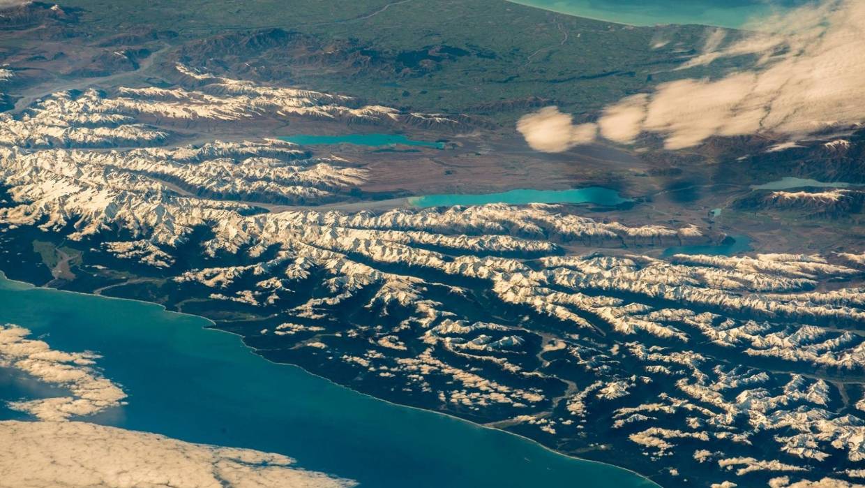
German astronaut’s amazing photos of New Zealand
Astronaut Alexander Gerst has shared stunning new images of New Zealand’s South Island yesterday from the International Space Station.
The images from the German astronaut, who works for the European Space Agency, provide a unique perspective, including a photograph of the Southern Alps that looks surreal.
Gerst posted the pictures with the caption: “It was in this fabulous country that I first learned what it means to travel beyond my horizons and how to see the world with open eyes.”

 November 14, 2018 at 9:52 am#835487
Jacek
ParticipantHi,
Earth is not flat.
Check out this blog. It explains it in simplest terms possible: https://flatearthisnonsense.blogspot.com/2018/11/why-cant-i-see-curvature.html
November 14, 2018 at 9:56 am#835488Jacek
ParticipantEarth is by no means flat.
Check this out: https://flatearthisnonsense.blogspot.com/2018/11/why-cant-i-see-curvature.html
November 14, 2018 at 10:17 am#835490 Dig4truthParticipant
Jacek, you should read the comments.
The curvature is measurable (by the ball earth experts) and it fails every time it’s tried! Check it out yourself. 8″ per mile squared. If it isn’t there you have to admit it is flat.
The next words of your post should be “I have measured it and it is…”
November 14, 2018 at 1:38 pm#835495 mikeboll64Blocked
D4T: T8, so your video admits that the global map is not correct? Good to know.
T8: I’m guessing you flunked science and I don’t have the time to point out every little detail. Maybe watch it again?
Somebody flunked science. Your pilot demonstrates two 90 degree angles, and then shows how they converge into a triangle. You don’t see a problem with that, T8? How many degrees in a triangle? How many degrees in two 90 degree angles? And if the base of the triangle consists of two 90 degree angles, how could they ever converge into a triangle at all? They would be exactly parallel to each other, and would never converge to form the top of the triangle.
November 14, 2018 at 1:46 pm#835496 mikeboll64Blocked
T8: Astronaut Alexander Gerst has shared stunning new images of New Zealand’s South Island yesterday from the International Space Station.
I wasn’t aware that NZ comprised half of the earth. 🙂 Continue the curve shown into a ball, and think about whether or not NZ should be taking up that much of it. I was also unaware that the ISS could take some images from 250 miles, then hover down to 20,000 feet to get those side-on views of the mountains.
T8, is it even remotely possible that the first image was taken with a fisheye camera on a high altitude weather balloon, and the latter from a regular old airplane?
November 14, 2018 at 2:04 pm#835497 mikeboll64Blocked
D4T: Jacek, you should read the comments.
The curvature is measurable (by the ball earth experts) and it fails every time it’s tried! Check it out yourself. 8″ per mile squared. If it isn’t there you have to admit it is flat.
The next words of your post should be “I have measured it and it is…”
Well said, D! Jacek, do you really want to discuss flat earth with us? Or were you just popping in to post the same old regurgitated misinformation that our community has rebutted time and time again?
Let me give you a hint here: If we cannot see a curve until we get far away from the earth, then the entire “boats going over the horizon” thing is shot down. Because if you can see a boat disappear over the curve from 3 or 4 miles away on your X axis (looking straight in front of you), then another person watching that same boat from your Y axis (90 degrees to your left or right) would be able to see the curve the boat disappeared behind on his horizon. Of course, as your source attests, nobody can look out on the ocean and see the curved horizon behind which the boat disappeared from the other person’s perspective, right?
Anyway, if you’re truly interested in discussing this matter, D4T and I are gladly up for it. If your intent is to just post a bunch of “flat earth debunked” articles and videos without actually discussing the many problems associated with them, then we’ve already had more than our fill.
November 15, 2018 at 12:20 pm#835506 mikeboll64Blocked
My latest…
November 16, 2018 at 8:52 pm#835555 ProclaimerParticipant
Welcome Jacek.
While we could refute all Flat Earth arguments in time, time is something we don’t have a lot of. So I appreciate you helping out here. I hope you can continue to post in this topic.
November 16, 2018 at 9:08 pm#835557 ProclaimerParticipant
I wasn’t aware that NZ comprised half of the earth. 🙂 Continue the curve shown into a ball, and think about whether or not NZ should be taking up that much of it.
They don’t change the size of the continents; they change the size of the horizon.
Photos of the Earth often show a full circular orb, but consider: only at an infinite distance would a photo of a spherical planet show a complete hemisphere. Any closer, and the line of sight of the camera will show the horizon somewhat closer. Because it’s still round, you may think you’re seeing an entire hemisphere, but you aren’t.
Have you ever noticed how a close “selfie” of someone will sometimes make his nose look huge? Meanwhile, his ears are out of sight around the sides of his head. It’s similar with space photos.
If you want to take photos of the Earth for some reason (to study deforestation, for example) the closer the better, and so most satellites intended to study the Earth are in LEO (Low Earth Orbit) only a couple hundred miles up. (This is also the altitude of the International Space Station, and where the shuttle operated.) At that altitude, it’s not really possible to get the whole planet in a single frame.
If you want to see some Earth system over a larger scale (weather systems, for example) you go higher, to a geostationary orbit at 22,3000 miles. It is from this altitude that the vast majority of “whole Earth” photos have been taken. But even that high, if a satellite is over the equator, both poles (and an equivalent part of the globe in every other direction) will be out of sight over the horizon, just like the ears of our selfie-taker. And since complete continents are seen lying on an incomplete hemisphere, the continents look “too big”, just like his nose.
The most “accurate” (proportionally speaking) photos of Earth were taken during the Apollo missions in the late ’60s and early ‘70s (aside from a few rare images captured when planetary probes revisited Earth for a gravity assist.) Because of their great distance from Earth, the astronauts going to and from the moon could see “over the edge” and capture almost a complete hemisphere, minimizing the distortion to which you refer.
Source: Quora
November 16, 2018 at 9:18 pm#835558 ProclaimerParticipant
I was also unaware that the ISS could take some images from 250 miles, then hover down to 20,000 feet to get those side-on views of the mountains.
It’s called a zoom lense.
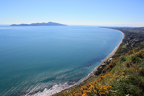
Consider these two photos I took from the exact same location. One is using a serious amount of zoom.
NOTE: The island in the second photo is out of range in the first. The first zooms in on a mountain in the background which is not visible in the second. The peninsula and sea are the only common thing in view. November 16, 2018 at 9:22 pm#835559
 ProclaimerParticipant
T8, is it even remotely possible that the first image was taken with a fisheye camera on a high altitude weather balloon, and the latter from a regular old airplane?
Yes it is remotely possible as you say. It is also remotely possible that I will win a major lottery one day.
November 18, 2018 at 12:06 am#835581 ProclaimerParticipant
This is my view too.
November 19, 2018 at 6:21 am#835611 mikeboll64Blocked
T8: …we could refute all Flat Earth arguments in time, time is something we don’t have a lot of.
But you can’t even refute a simple picture of Chicago from Michigan. Or your own photo of Ruapehu for that matter. Do you understand that, T8? A simple photograph destroys your entire model – without even bringing in the hundreds of other irrefutable points we’ve compiled.
November 19, 2018 at 6:40 am#835612 mikeboll64Blocked
T8: It’s called a zoom lense.
Zoom lenses don’t change the perspective from on top shooting down to down low shooting from the side.
November 19, 2018 at 6:49 am#835613 mikeboll64Blocked
T8: This is my view too.
Sadly, that’s because you and the guy in the video hold the imaginative but unverifiable stories of the godless priests of scientism in higher regard than the inspired words of He who created the heavens, the earth, the sea, and everything in them.
God says He did it in 6 days. You and the priests you exalt say otherwise.
God says He created the sun on day four. You and the priests to which you cling say otherwise.
It’s truly just a matter of who you hold as a higher authority. Our Creator… or godless men who promote the idea that we don’t have a Creator at all.
November 20, 2018 at 11:05 am#835663 ProclaimerParticipant
Zoom lenses don’t change the perspective from on top shooting down to down low shooting from the side.
Look again. The unzoomed or less zoomed image is side on too. So if you zoom into a subject from the side, you will still see the side even more right? I know, I have been taking photos for decades. It is one of my favourite hobbies. This particular rebuttal of yours is very weak.

- AuthorPosts
- You must be logged in to reply to this topic.


